

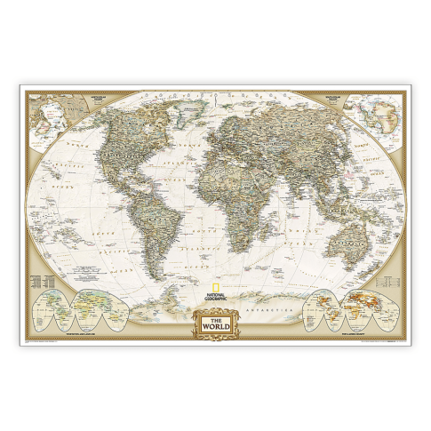
National Geographic World Executive Map, Poster Size and Laminated, 36in x 24in MPN:NGMRE01020376
Discount: See in Cart
Free Shipping
In Stock
Free Shipping
In Stock
SKU
312-4347356
National Geographic World Executive Map, Poster Size and Laminated, 36in x 24in MPN:NGMRE01020376
Elevate your office or home decor with the National Geographic World Executive Map, a visually stunning and informative poster that showcases the world in exquisite detail. Perfect for executives, educators, and world travelers, this map is expertly researched and designed to provide a comprehensive understanding of global geography. Its antique-style color palette and laminated finish make it a durable and stylish addition to any room, while its corner inset maps and detailed features offer a wealth of information for anyone interested in the world. Use it for educational purposes, as a conversation starter, or simply to admire the beauty of our planet.
Top product features:
- Expertly researched and designed, the map is the authoritative reference of the world by which other maps are measured.
- The map uses a combination of conventional English names, official national names, and standard transliterations for non-Latin alphabets.
- The map is drawn in Winkel Tripel projection with distortions minimized, providing a more accurate representation of the world.
Top product applications:
- Office Wall Decoration
- Educational Tool for Geography Classes
- Travel Planning and Research
Expertly researched and designed, National Geographics World Wall Map is the authoritative map of the world by which other reference maps are measured. Antique-style "executive" color palette. Background shows mountain ranges and valleys in subtle shaded relief with mountain ranges labeled. Major water bodies including rivers, lakes, glaciers, oceans, seas, gulfs, bays, straits, and bathymetry. Clearly defined international boundaries, cities, islands, airports, and physical features. Thousands of place names carefully and artfully placed to maintain legibility in heavily populated areas. Up-to-date international boundaries and territorial control reflect de facto status on the ground. Meticulously researched using multiple authoritative sources including the U.N., U.S. Board on Geographic Names, and policies of individual governments. Accurate place names use a combination of conventional English names, official national names, and standard transliterations for non-Latin alphabets. Drawn in Winkel Tripel projection with distortions minimized unlike other World maps (e.g. Greenland is shown the same size as Argentina, not South America). Corner inset maps feature vegetation, land use, population density, and north and south polar regions. The 36in x 24in poster size supports easy and affordable framing and mounting, and takes less wall space than standard wall maps. The map is encapsulated in heavy-duty 1.6 mil laminate which makes the paper much more durable and resistant to the swelling and shrinking caused by changes in humidity. Laminated maps can be framed without the need for glass, so the frames can be much lighter and less expensive.
Additional Information
- Country of Origin: US
- UNSPSC Code: 60101721
- UNSPSC Commodity: Professional teacher resource books
- Green: No
- Recycled Content: FALSE
- Hazardous: No
- Prop 65: No
- MSDS URL: nan
- Package Length: 32.00
- Package Width: 2.00
- Package Height: 2.00
- Package Weight: 0.25
Product info last updated on February 23, 2026 6:15am UTC
Category: Instructional Resources