

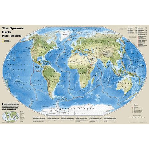
National Geographic The Dynamic Earth, Plate Tectonics Map, Laminated, 36in x 24in MPN:NGMRE01020634
Discount: See in Cart
Free Shipping
In Stock
Free Shipping
In Stock
SKU
312-3466150
National Geographic The Dynamic Earth, Plate Tectonics Map, Laminated, 36in x 24in MPN:NGMRE01020634
The Dynamic Earth map illustrates plate tectonics and features stunning bathymetry and naturally colored relief, as well as volcano and earthquake data through 2011. Like pieces of a giant jigsaw puzzle, tectonic plates fit together to form the earths outer shell. The interaction of these plates causes earthquakes and volcanoes and shapes the earths crust into mountains, valleys and deep-sea trenches. The Dynamic Earth map illustrates 17 major tectonic plates and highlights diffuse plate boundaries, convergent boundaries, spreading boundaries, fault zones, hot spots, notable earthquakes and volcanic eruptions of the 20th and 21st centuries, earthquakes with a magnitude of greater than 6.5 during the 20th and early 21st centuries, and notable volcanic eruptions during the past 10,000 years. The map is encapsulated in heavy-duty 1.6 mil laminate which makes the paper much more durable and resistant to the swelling and shrinking caused by changes in humidity. Laminated maps can be framed without the need for glass, so the frames can be much lighter and less expensive. Measures 36in x 24in.
Additional Information
- Country of Origin: US
- UNSPSC Code: 60101721
- UNSPSC Commodity: Professional teacher resource books
- Green: No
- Recycled Content: FALSE
- Hazardous: No
- Prop 65: No
- MSDS URL: nan
- Package Length: 32.00
- Package Width: 2.00
- Package Height: 2.00
- Package Weight: 0.25
Product info last updated on February 11, 2026 5:13pm UTC
Category: Instructional Resources